 Læs op
Opdatering om fjeldskredsaktivitet i Nuussuaq-halvø, vest for Tupaasat
Sendes af: Departementet for Råstoffer og Justitsområdet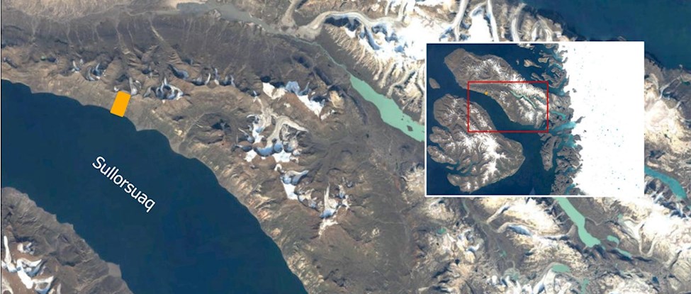
Den 17. juli 2023 udsendte Departementet for Råstoffer og Justitsområdet meddelelse om en bevægelse på en skråning på sydsiden af Nuussuaq i løbet af vinteren 2022-23. Se figur 1.
Siden har geologerne fra Departementet for Råstoffer og Justitsområdet undersøgt omfanget af skreddet på Nuussuaq-halvøen. Se fig. 2.
Det meste af det materiale der faldt, blev standset af en flad terrasse omkring 550 meter over havet. En mindre mængde materiale er gledet ned gennem kløfter og vandholdig jord og sten er spredt ud på skråningen uden at nå kysten. Se figur 3.
Geologerne forventer, at der stadig kan ske mindre skred ned i de underliggende kløfter, specielt ved nedbør eller tøbrud. Enkelte skred kan ende i fjorden, men kun til fare i umiddelbar nærhed af skredområdet.
Geologiske og klimatiske forhold kan muligvis udvikle nye skred. Geologerne holder derfor øje med området via satellitdata og luftfotos.
Departementet for Råstoffer og Justitsområdet anbefaler stadig, at borgere færdes med varsomhed ved kystområderne langs Nuussuaq-halvø, da det ikke kan udelukkes, at der kommer flere skred.
Hvis man er i besiddelse af lokal viden om ustabile fjeldpartier, eller observerer stenslag og lignende, bedes man kontakte geologiafdelingen via indberetningsformularen på hjemmesiden:
https://govmin.gl/da/fjeldskred-og-overvaagning/indberetning-2/#formular
Informationer fra borgerne bidrager til lokalisering af ustabile fjeldskråninger i Grønland.
For yderligere information kontakt departementschef Jørgen T. Hammeken-Holm på e-mail joeh@nanoq.gl eller telefon +299 346846.
------------------------------------------------------------------------
Press Release: Update on landslide activity in Nuussuaq Peninsula, west of Tupaasat
On 17 July 2023, the Ministry of Mineral Resources and Justice issued a public announcement about landslide movement on a slope on the south side of Nuussuaq-peninsula during the winter of 2022-23.
Geologists from the Ministry of Mineral Resources and Justice have recently visited the site to examine the extent of the landslide. See figure 2.
Most slide material was stopped by a flat terrace about 550 metres above sea level. A small amount of material has slid down through ravines, and water-laden soil and rocks have spread out without reaching the coast. See figure 3.
Figure. 1. Overview map. The area with landslide activity is marked with the orange-colored polygon
Geologists expect that minor landslides may still occur ireaching underlying canyons, especially during precipitation or thawing. Some landslides may end up in the sea but impose danger only in the immediate vicinity of the landslide area.
Geological and climatic conditions may lead to development of new landslides. Geologists continue to monitor the area via satellite data and aerial photos.
The Ministry of Mineral Resources and Justice still recommend that citizens travel with caution in the coastal areas along the Nuussuaq-peninsula, as more landslides may occur.
If you have local knowledge of unstable mountain areas or observe rockfalls and the like, please contact the geology department via the report form on the website:
https://govmin.gl/da/fjeldskred-og-overvaagning/indberetning-2/#formular
Information from citizens contributes to the localization of unstable mountain slopes in Greenland.
For further information please contact Permanent Sectretary, Jørgen T. Hammeken-Holm, via e-mail joeh@nanoq.gl or phone +299 346846.

Figur. 1. Oversigtskort. Området med skredaktivitet er markeret med orangefarvet firkant./
Figure. 1. Overview map. The area with landslide activity is marked with the orange-colored polygon

Figur 2. Det nye skredområde med bagvæg i gult. Længde af området er ca. 400 meter, og bagvæggets tykkelse vurderes til at være omkring 20 - 50 meter/
Figure 2. The new landslide area with back-escarpment in yellow dashed line. The length of the area is approximately 400 meters, and the thickness of the back escarpment is estimated to be around 20 - 50 metres.

Figure 3. The debris flow deposits of soil and rock from the landslide event are visible as dark matierial on the image. The deposits thin out towards coastal areas and do not reach the coast.